


The Pilger Twins: June 16, 2014 - When Nature Created a Double Feature
The day Nebraska witnessed one of the most spectacular and tragic tornado displays in meteorological history

Hello, weather watchers! Today marks exactly eleven years since one of the most extraordinary atmospheric phenomena ever captured on film - the day Mother Nature decided to put on a terrifying double act that would rewrite the textbooks on supercell behavior.
The Atmospheric Stage: Perfect Chaos Brewing
June 16, 2014, started like any other late spring day in eastern Nebraska. But high above our heads, the atmosphere was orchestrating something unprecedented. A powerful upper-level trough was diving southeastward from Canada, creating the perfect recipe for atmospheric violence.
The Meteorological Setup:
Temperature Shear: Surface temps in the 80s colliding with frigid air aloft
Wind Shear: Dramatically changing wind speeds and directions at different altitudes
Moisture Transport: Gulf of Mexico moisture streaming northward like an atmospheric fire hose
Lifting Mechanism: A powerful cold front acting as nature's launching pad
What made this day extraordinary wasn't just the individual ingredients - it was how they combined in perfect, devastating harmony. The atmospheric profile showed what meteorologists call "loaded gun sounding" - maximum instability with extreme wind shear, the hallmark signature of violent tornado potential.
The Birth of Giants: Supercell Genesis
By mid-afternoon, towering cumulonimbus clouds began exploding skyward like atmospheric skyscrapers. These weren't ordinary thunderstorms - these were supercells, rotating mesocyclones with updrafts so powerful they could lift cars and buildings into the sky.
The storm complex developed multiple mesocyclones - think of them as atmospheric engines, each one capable of spawning its own tornado. But on this day, something unprecedented happened: two tornadoes formed simultaneously from the same parent supercell.
The Atmospheric Mechanics:
Mesocyclone Splitting: The parent rotation divided into two distinct circulation centers
Occlusion Process: Each circulation developed its own low-level mesocyclone
Tornado-genesis: Both reached the surface within minutes of each other
Storm chasers watching this unfold described it as witnessing atmospheric history. Two massive tornadoes, spinning side by side like deadly dancers, moving across the Nebraska landscape with terrifying precision.
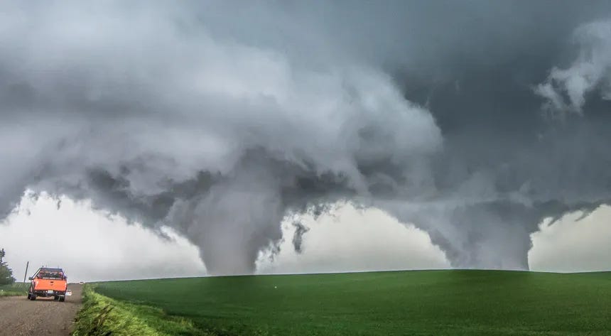
The Pilger Twins: EF4 Atmospheric Monsters
At approximately 3:45 PM local time, both tornadoes reached peak intensity as they approached the small town of Pilger (population 352). These weren't just tornadoes - they were meteorological monsters, both rated EF4 on the Enhanced Fujita Scale.
The Twin Tornadoes' Vital Statistics:
Maximum Winds: 180+ mph in both vortices
Path Width: Up to 400 yards each
Forward Speed: 25-30 mph
Duration: Nearly 30 minutes of peak intensity
What made this event truly extraordinary was the interaction between the two vortices. They exhibited what meteorologists call the "Fujiwara Effect" - when two rotating systems influence each other's movement. The tornadoes would approach each other, then separate, creating a deadly atmospheric ballet across the countryside.
The Meteorological Marvel: Satellite Mesocyclones
High-resolution Doppler radar captured something remarkable - the velocity couplets (rotating wind signatures) were so intense they appeared as perfect red and green spirals on weather displays. The tornadic vortex signatures (TVS) showed rotation velocities exceeding 150 mph at 500 feet above ground level.
Radar Signatures Revealed:
Velocity Couplets: Extreme wind shear creating tight rotation signatures
Bounded Weak Echo Regions: Classic supercell structure with embedded mesocyclones
Three-Body Scatter Spikes: Indicating debris lofted to extreme altitudes
Storm chasers positioned themselves at safe distances, capturing footage that would become legendary in meteorological circles. The visual spectacle was both beautiful and terrifying - two massive condensation funnels, perfectly formed, moving across the green Nebraska farmland like atmospheric titans.
The Human Impact: When Weather Meets Community
While we marvel at the meteorological mechanics, we must remember the human story. The town of Pilger was devastated - 75% of the town was damaged or destroyed. Miraculously, thanks to advanced warning systems and the courage of storm spotters, only two fatalities occurred.
The Warning Success Story: The National Weather Service issued tornado warnings 13 minutes before the first tornado touched down. Local emergency managers, trained storm spotters, and broadcast meteorologists worked in perfect coordination to save lives. This event showcased how modern meteorology, when combined with community preparedness, can minimize tragedy even during extreme weather events.
The Atmospheric Aftermath: Scientific Gold Mine
The Pilger event became a case study for tornado researchers worldwide. The combination of high-resolution mobile radar data, photogrammetric analysis of the tornadoes, and detailed damage surveys provided unprecedented insights into violent tornado dynamics.
Scientific Discoveries:
Multiple Vortex Structure: Both tornadoes exhibited complex internal vortex interactions
Tornado Interaction Dynamics: First documented case of twin EF4 tornadoes from the same supercell
Ground Truth Validation: Perfect correlation between radar signatures and actual damage patterns
Weather Watch Takeaway: The Atmospheric Dance Continues
The Pilger Twins of June 16, 2014, remind us that our atmosphere is capable of creating phenomena that still humble even the most advanced meteorological minds. These twin tornadoes weren't just weather - they were atmospheric art, painted across the Nebraska sky with winds that could level buildings.
Modern Meteorological Lessons:
Supercell Splitting: Understanding how rotating storms can spawn multiple tornadoes
Warning Lead Times: The importance of continuous atmospheric monitoring
Community Resilience: How weather education and preparedness save lives
Today, as we look back on this extraordinary June 16th, we're reminded that every atmospheric event tells a story. The Pilger Twins told a story of nature's incredible power, human resilience, and the critical importance of understanding our sky.
The Atmospheric Memory: Every time meteorologists see similar atmospheric setups, they remember Pilger. The signatures, the dynamics, the perfect storm of conditions that created one of the most visually spectacular and scientifically valuable tornado events in recorded history.
Next time you see a tornado watch issued for eastern Nebraska in mid-June, remember the Pilger Twins - the day the atmosphere decided to put on a show that redefined our understanding of supercell tornadoes.
Keep watching the skies,
The Weather Watch Team 🌪️
Remember: The atmosphere never stops teaching us. Our job is to listen, learn, and share the stories written in wind and cloud.
Those Pilger Twins looked fierce!