
🔥 The Summer's Turning Point: When Severe Weather Meets Extreme Heat
Decoding the atmospheric signals that are orchestrating a dangerous weather symphony

Good morning, Weather Watchers! Today's atmospheric story is like watching the opening scene of a meteorological thriller. We're in that eerie calm period where the sky seems peaceful, but the atmosphere is secretly orchestrating what could be one of the most significant weather events of the summer.
The Plot Thickens: What's Happening Right Now
Yesterday was surprisingly quiet across most of the country—the kind of deceptive calm that makes meteorologists lean forward in their chairs. We had some scattered severe weather from northern New England back into the central plains, with several tornado warnings lighting up northern Maine (yes, Maine can get tornadoes too!). Meanwhile, the remnants of what could have been Tropical Storm Dexter fizzled out as it moved into Louisiana, keeping our next Atlantic name on standby.
But here's where the story gets interesting: the atmosphere is setting the stage for something much bigger.
The Main Characters: Two Weather Systems Ready to Steal the Show
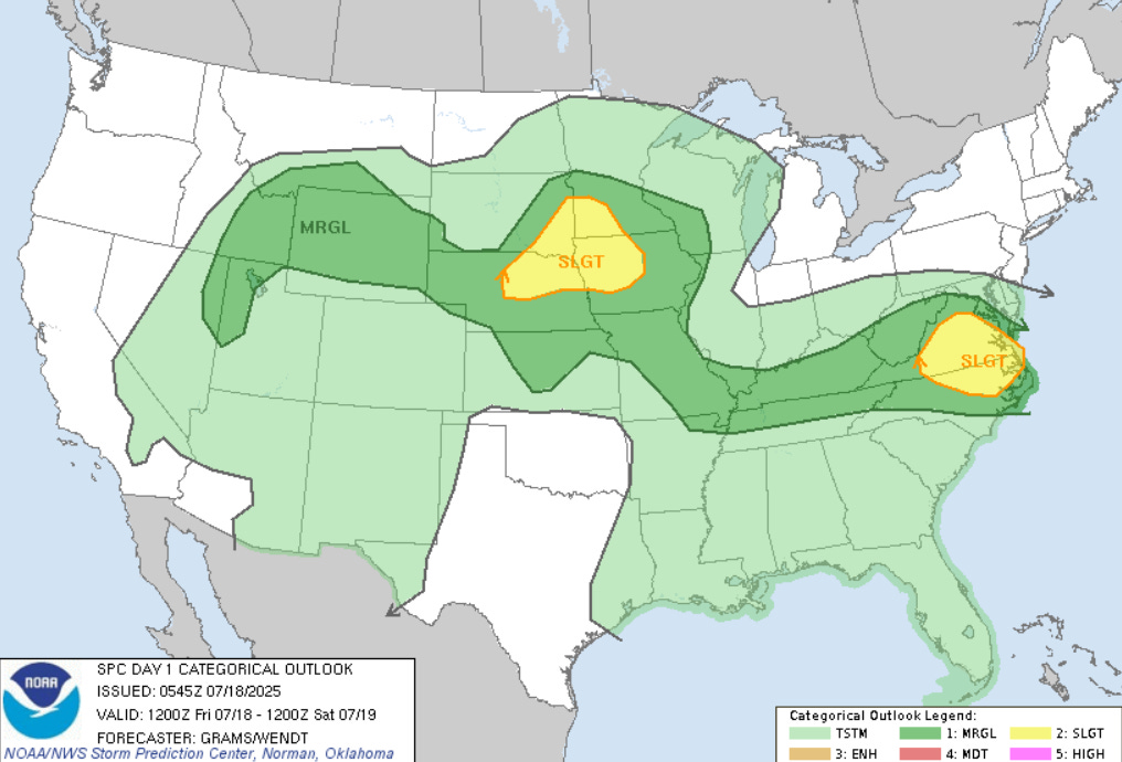
Today's Setup: The Opening Act We're dealing with two distinct severe weather zones today—think of them as the opening acts before the main performance. The first stretches across the central plains, while the second takes the stage in the Mid-Atlantic. There's even a narrow corridor of potential severe weather reaching all the way into Nevada, creating this fascinating atmospheric highway of instability.
The greatest concern today? Damaging winds. I'm watching northwestern Iowa particularly closely because conditions are ripe for what we call a "squall line"—essentially a wall of thunderstorms that can produce widespread wind damage. Large hail is also on the menu, especially for those initial storms that fire off this afternoon and evening across Nebraska, Iowa, Minnesota, and South Dakota.
The Tornado Angle: A Conditional Threat Here's where it gets meteorologically fascinating: we have what's called a "conditional tornado threat" near Sioux Falls and Sioux City. It all depends on whether storms can maintain their individual identity (what we call "discrete supercells") rather than merging into lines. If they stay separate, the rotating updrafts have room to breathe, and that's when tornadoes become more likely.
Saturday's Sequel: The Plot Expands
Saturday is when this weather story really picks up momentum. We're looking at a large area under slight risk for severe weather, encompassing the Midwest and northern Ohio Valley. This is going to be primarily a wind event—imagine a massive line of thunderstorms marching eastward like a weather army.
The timing is crucial here: storms that develop Friday evening will congeal into a significant line overnight, potentially bringing dangerous winds to Des Moines and eastern Iowa in the pre-dawn hours. By Saturday morning, this system will be knocking on Chicago's door, then continuing its march through Indiana, southern Michigan, Ohio, and Kentucky.
Sunday's Continuation: The Northern Plains Take Center Stage
Sunday shifts our focus back to the northern and central plains, where we might see some impressive supercells develop during the late afternoon and evening. The Dakotas are particularly interesting—we could see isolated strong tornadoes, especially if atmospheric conditions align just right.
The Bigger Picture: An Active Pattern Emerges
What makes this weather story truly compelling is that it's not just a weekend event. We're entering what meteorologists call an "active pattern," where the jet stream and upper-level winds create a highway for repeated storm systems. Think of it as the atmosphere getting stuck in a particular gear, one that favors storm development.
I'm particularly watching Tuesday and Wednesday of next week, which could feature the most significant severe weather potential across the Midwest and central plains. It's like the atmosphere is building toward a crescendo.
The Heat Wave Subplot: A Dangerous Supporting Character
While we're focused on the severe weather drama, there's a secondary story developing that's equally important: extreme heat. A massive upper-level ridge (think of it as a dome of high pressure) is building across most of the country, and it's going to create what could be record-breaking temperatures.
By the middle of next week, we're looking at actual temperatures (not heat index) in the low 100s across Kansas, Oklahoma, Louisiana, and Arkansas. But here's the jaw-dropping part: by late July, some areas near Omaha and central Nebraska could see temperatures approaching 110-115°F.
When you factor in humidity, the heat index could reach dangerous levels across a massive area, potentially from South Carolina to Minnesota. This isn't just uncomfortable—it's potentially life-threatening, especially for vulnerable populations.
What This Means for You
This is one of those weather stories where preparation is key. If you're in the severe weather zones, make sure you have multiple ways to receive warnings, especially overnight. Nocturnal tornadoes are among the most dangerous because people are sleeping and can't see them coming.
For the heat wave, now is the time to plan. Check on elderly neighbors, ensure your cooling systems are working, and limit outdoor activities during peak heat hours.
Conclusion
What fascinates me most about this pattern is how it showcases the atmosphere's incredible complexity. We have severe weather systems dancing with heat domes, tropical remnants playing supporting roles, and jet stream patterns conducting the entire orchestra. It's a reminder that weather isn't just about individual storms—it's about the interconnected systems that create the sky's daily drama.
This is exactly the kind of weather story that makes me excited to be your weather storyteller. We're not just looking at forecasts; we're watching the atmosphere write its own compelling narrative, complete with plot twists, building tension, and dramatic climaxes.
Stay weather-aware, stay prepared, and most importantly, stay curious about the amazing atmospheric theater happening right above our heads.
Keep watching the skies,
The Weather Watch Team 🌪️